gordon.dewis.ca - Random musings from Gordon

Subscribe

Archive for the ‘Weather’

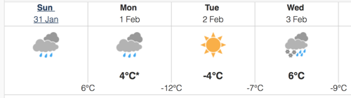
Seriously? Snow in the forecast? Why?

April 25, 2016 @ 15:31 By: gordon Category: General, Weather

Have we done something wrong? I just took a look at the aviation forecast for Ottawa and am a bit unimpressed as result:

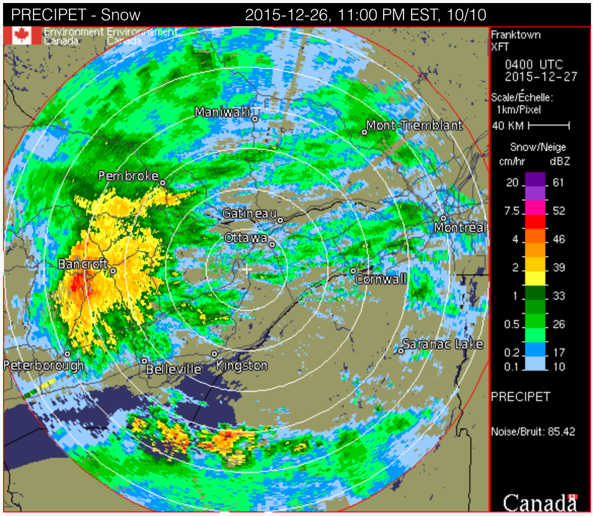
TAF CYOW 251738Z 2518/2618 30007KT P6SM BKN220 
 FM260000 VRB03KT P6SM BKN160 
 FM260600 05010KT P6SM OVC090 
 FM261100 07012KT 3SM -SN OVC060 
 FM261500 06012KT P6SM BKN120 
 RMK NXT FCST BY 252100Z=

As you can see in the line I’ve highlighted in red, there’s light snow forecast between 7AM (1100Z) and 1PM (1500Z).

If this actually happens, the morning commute will be insane as everyone has forgotten how to drive in the snow by now. Some of my coworkers have had their snow tires removed, too.

I know that the snow won’t hang around, but I really really really don’t want any more snow. (Ever.)

Gordon’s Rule for TAFs

March 01, 2016 @ 13:41 By: gordon Category: Weather

Terminal area forecasts (TAFs) are aviation weather forecasts. They are very precise and typically cover the next 24 to 36 hours from the time they’re issued. Each period within the TAF provides information on the winds, clouds and precipitation expected to occur. There are also optional sections that may appear for temporarily occurring weather (less than an hour) and for weather than may occur (30% and 40% probability). The latter is usually only for “bad” weather that could impact flight safety.

Gordon’s Rule for TAFs is simple: The longer the forecast, the more unsettled (aka “crappy” (a highly technical term)) the weather is going to be.

Here’s the TAF for Ottawa that was issued over the lunch hour:

TAF CYOW 011738Z 0118/0218 26005KT P6SM BKN120 OVC220 
     FM012000 05005KT P6SM -SN OVC070 
      TEMPO 0120/0122 4SM -SN 
     FM012200 06010KT 2SM -SN VV015 
      TEMPO 0122/0124 4SM -SN OVC050 
     FM020000 06012KT 11/2SM -SN VV012 
      TEMPO 0200/0202 3/4SM -SN VV008 
     FM020200 06015G25KT 1/2SM SN BLSN VV005 
     FM020500 06020G30KT 1/4SM +SN BLSN VV002 
      BECMG 0208/0210 04015G25KT 
     FM021100 35015G25KT 3/4SM -SN BLSN VV008 
     FM021300 31018G28KT 2SM -SN BLSN OVC025 
     FM021700 29018G28KT 5SM BLSN BKN030 
      RMK NXT FCST BY 012100Z

Ick.

No redeeming features

February 23, 2016 @ 22:21 By: gordon Category: Weather

I can see no redeeming features in the forecast for the next day or so:

TAF CYOW 240238Z 2403/2424 05005KT P6SM OVC040 TEMPO 2406/2408 P6SM -SN BKN020 OVC040
FM240800 03005KT P6SM -SN FEW010 BKN020 OVC040 TEMPO 2408/2410 P6SM NSW BKN025 OVC040
FM241000 02005KT P6SM -SN SCT008 OVC020 TEMPO 2410/2414 3SM -SN BKN008 OVC020 PROB30 2410/2414 2SM -SN -FZDZ BR OVC004
FM241400 05010KT 11/2SM -SN OVC008 TEMPO 2414/2417 3SM -SN OVC020
FM241700 06015G25KT 1/2SM SN BLSN VV005
FM242000 07015G25KT 1SM -SNPL OVC006 PROB30 2420/2422 1/2SM SN BLSN
FM242300 07015G25KT 2SM -FZRA BR OVC006
RMK NXT FCST BY 240600Z=

Light snow. Light snow with light freezin drizzle. Moderate snow. Blowing snow. Snow pellets. Light freezing rain. And increasing amounts of wind as time marches on.

Nope, not a single redeeming feature.

What did we do to deserve this?

February 19, 2016 @ 22:06 By: gordon Category: Weather

So, a quick recap of this week:

  • Bloody freezing cold
  • Ludicrous amounts of snow
  • A bit more snow
  • Cold

And now this:

TAF AMD CYOW 200030Z 2000/2024 09015KT 3/4SM -TSSN OVC015
TEMPO 2000/2001 2SM -SN OVC020
FM200100 09014KT 2SM -SN OVC015
TEMPO 2001/2003 6SM -SN
FM200300 11015KT 11/2SM -SN VV012
TEMPO 2003/2011 1/2SM SN VV005 PROB30 2003/2007 3/8SM SHSN
FM201100 19015G25KT 2SM -RA BR SCT008 OVC015
FM201500 24020G30KT P6SM -SHRA OVC020
FM201900 24015G25KT P6SM -SHRA OVC030
RMK NXT FCST BY 200300Z

Essentially, light thundersnow (!) with periods of light snow followed by light snow with periods of moderate snow and possible snow showers. Then light rain and mist, silly amounts of wind with light rain showers. All between 7pm this evening and 2pm Saturday.

Eww

January 31, 2016 @ 15:59 By: gordon Category: Weather

Environment Canada just issued this:

Issued at 2016-01-31 20:32 UTC by Environment Canada:
Special weather statement issued for:
Gatineau, Que. (031100)
City of Ottawa, Ont. (045400)
Current details:
A winter storm is expected to develop over the United States central plains on Monday and track northeastward reaching the Great Lakes late Tuesday night. The storm is expected to bring periods of heavy snow over Central and Eastern Ontario Tuesday night before gradually transition to rain Wednesday morning. At this time, total snowfall amounts remain uncertain. The primary threat with this storm appears to be the risk of freezing rain and ice pellets which is expected to accompany the snow Tuesday night before transitioning over to rain especially over locations east of Georgian Bay to the Ottawa Valley. Gusty winds will accompany the approaching storm before gradually diminishing late Wednesday night as the storm moves out of the area and into Quebec.

From the sounds of it, it actually sounds like we’ll be ok compared to other parts of the province, but Wednesday could rate quite high on the suck-o-meter.

The Arrival of Winter 2015 in 1m18s

December 29, 2015 @ 13:32 By: gordon Category: Photography, Weather

I set my GoPro to take a photo every 10 seconds last night. The resulting time lapse is pretty cool:

Insta-winter

December 26, 2015 @ 11:35 By: gordon Category: Weather

One of the presents I received for Christmas this year is a small can with a pull top on it. Inside is, apparently, 20 grams of “stuff” that poofs up into about 1.5 litres of artificial snow when you add a small amount of water. (I say apparently because I haven’t opened it, yet.)

Looking at the Franktown radar, it appears that parts of the Ottawa Valley may have popped the top on a giant version of a can of this stuff:

Poor Bancroft appears to be sitting on the boundary between freezing rain and snow.