


Are Ottawa’s winters less snowy? It depends on how you look at it.
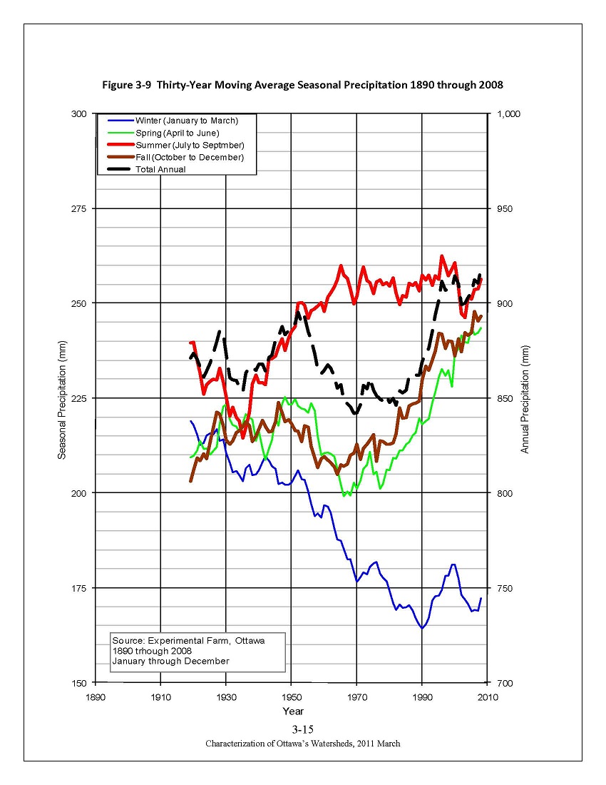 Charles over at Guide Gatineau posted an interesting article this morning looking at the implications of climate change on skiing and snowshoeing in the Ottawa area. He included a graph showing a the 30-year moving average of seasonal precipitation recorded at the Experimental Farm between 1890 and 2008. He asks “Do my eyes deceive me or does it look to you as if today we get only something over 1½ metres”, and based on the graph at first glance he’s not wrong — in the last few years we’ve averaged around 160cm of snow per winter.
Looking at the graph in question, it does appear that there has been less snowfall recorded at the Experimental Farm’s weather station recently compared to the start of the record, though the total annual precipitation, including both rain and snow, shows an upward trend over time. There are many factors that could be affecting the snowfall accumulation data. For example, over the years the Experimental Farm has gone from being in a rural setting to an urban setting by virtue of the fact that the city has grown around it. If the weather observation site had remained in a rural environment, the snowfall record might be quite different. Trees and buildings around the Farm have gotten bigger over the years, which probably has had an impact on the wind patterns at the Farm. This could result in less drifting snow, which could result in less accumulation.
Another thing about the graph is that seasonal precipitation is reported in millimetres. Presumably, they’re using a 10:1 conversion factor for snow:water, though they could have melted a column of snow and recorded the actual amount of water — either method is fine for our purposes. The blue line represents January to March precipitation, most of which is probably snow, but could be rain or some other type of precipitation like hail. The brown line represents October to December and this is where things get a bit problematic because there’s a fair chance that precipitation in those months can be a mix of rain and snow. Without a distinction between rain and snow, we have no way of knowing how much snow we should be adding to the snow calculated from the blue line to get a reasonable estimate of the total snowfall. In other words, using just the blue line to calculate the amount of snow results in under estimation.
Intrigued by Charles’ graph, I decided to do my own analysis using monthly weather data from Environment Canada’s Climate Data website. The results are interesting and tell a slightly different story from the data in the graph from the Experimental Farm.
 AKA Keeper of Maps, I'm a geocacher who lives in Ottawa, Canada.
