Are Ottawa’s winters less snowy? It depends on how you look at it.
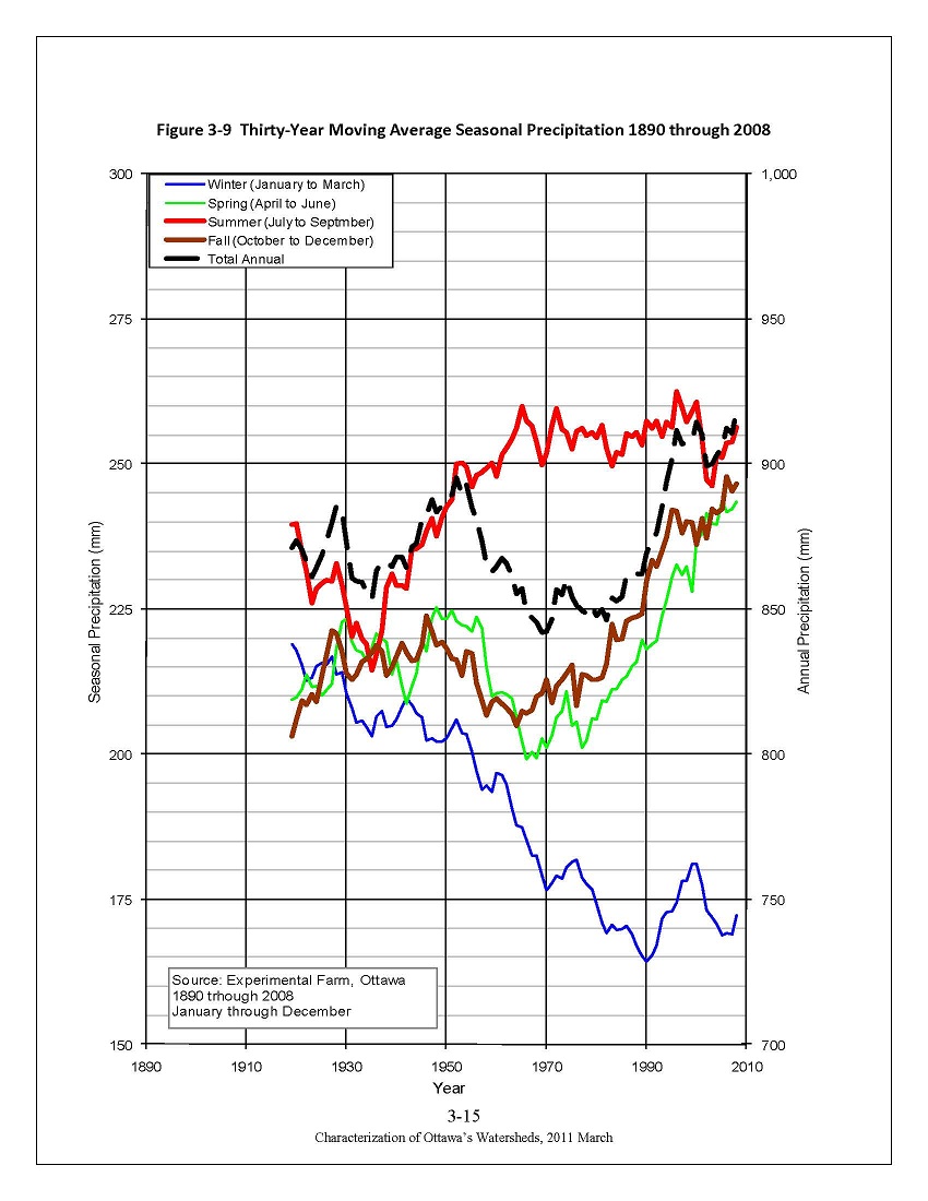
 Charles over at Guide Gatineau posted an interesting article this morning looking at the implications of climate change on skiing and snowshoeing in the Ottawa area. He included a graph showing a the 30-year moving average of seasonal precipitation recorded at the Experimental Farm between 1890 and 2008. He asks “Do my eyes deceive me or does it look to you as if today we get only something over 1½ metres”, and based on the graph at first glance he’s not wrong — in the last few years we’ve averaged around 160cm of snow per winter.
Looking at the graph in question, it does appear that there has been less snowfall recorded at the Experimental Farm’s weather station recently compared to the start of the record, though the total annual precipitation, including both rain and snow, shows an upward trend over time. There are many factors that could be affecting the snowfall accumulation data. For example, over the years the Experimental Farm has gone from being in a rural setting to an urban setting by virtue of the fact that the city has grown around it. If the weather observation site had remained in a rural environment, the snowfall record might be quite different. Trees and buildings around the Farm have gotten bigger over the years, which probably has had an impact on the wind patterns at the Farm. This could result in less drifting snow, which could result in less accumulation.
Another thing about the graph is that seasonal precipitation is reported in millimetres. Presumably, they’re using a 10:1 conversion factor for snow:water, though they could have melted a column of snow and recorded the actual amount of water — either method is fine for our purposes. The blue line represents January to March precipitation, most of which is probably snow, but could be rain or some other type of precipitation like hail. The brown line represents October to December and this is where things get a bit problematic because there’s a fair chance that precipitation in those months can be a mix of rain and snow. Without a distinction between rain and snow, we have no way of knowing how much snow we should be adding to the snow calculated from the blue line to get a reasonable estimate of the total snowfall. In other words, using just the blue line to calculate the amount of snow results in under estimation.
Intrigued by Charles’ graph, I decided to do my own analysis using monthly weather data from Environment Canada’s Climate Data website. The results are interesting and tell a slightly different story from the data in the graph from the Experimental Farm.
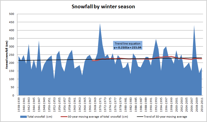
Generally speaking, when you look for longer term trends in weather, you use a 30-year average. This attenuates the effect of extreme weather events, such as the big snowfall in the winter of 1970-1971 or 2007-2008, on your analysis.
Environment Canada’s dataset for Ottawa that I used has snowfall records going back to November 1938. I’ve grouped the data by winter season rather than calendar year, to more accurately try to reflect the amount of snowfall during the winter.
The blue in the graph is the snowfall during the winter, measured in centimetres. The red line is the 30-year moving average and the black line is the linear trend line for the 30-year moving average. As you can see, there’s a lot of variation from one year to the next in terms of the amount of snow that fell. You can see the big dump in the winter of 1970-1971 that saw Ottawa receive over 150cm in February, and the winter of 2007-2008 that saw almost as much snow. But, when you look at the 30-year moving average, you can see that it’s fairly steady as the 30-year window advances, and it’s only when you look at the trend line for the moving average that you see that it’s actually trending upwards. (The coefficient of 0.2101 in the equation y=0.2101x + 215.04 means that the 30-year average is increasing as time marches on.) And the trend line for the annual data (not shown) has a positive slope, too.
Given that from a statistical point of view, Ottawa’s winters have been seeing more snow than they have in the past (assuming the past starts in November 1938) why does it feel like our winters are less snowy than those of our childhoods?
Well, it could be because there might be fewer large snowfall events (i.e. big dumps of snow) during a winter allowing for the snow on the ground to compact. In the 477 months that had some amount of snowfall reported, the average was 34.8cm.
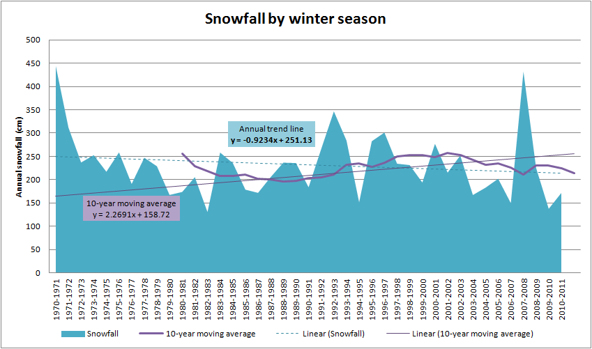
Or it could be that when you’re comparing the last few winters to those of your childhood. And when we look at the annual data for the last decade or so there is actually slight downward trend in the amount of snow that fell each winter, but that’s a relatively short term trend, not a long term trend.
Or it could be that we’re bigger now than we were when we were young so everything that once was big isn’t quite so big anymore.
For the record, when I looked at the trend based on the annual data for the winters since I was born in 1969, there’s a slight downward trend based on the annual data, but a 10-year moving average shows an upward trend. (I would have used a 30-year moving average, but that would give only thirteen observations given my age. ![]() )
)


 AKA Keeper of Maps, I'm a geocacher who lives in Ottawa, Canada.

Hey Gordon
To start I’ll admit I amped-up the eyeballed snow depth off the first graph http://j.mp/wjae9J
The text of the City of Ottawa document actually says:
“Winter precipitation has dropped from 220 mm/year in the 1920s and 1930s down to the current 170 mm/year with the most significant decreases in the months of January and February”
So to me, the question becomes – both can’t be true; that we get less snow than we used to, and that we get more snow than we used to. Which is it?
I’ve submitted a query to Environment Canada asking for their guidance.
Cheers
Charles
There are probably two or three things coming into play here. First, you were looking at data from the Experimental Farm while I looked at data from Environment Canada. Second, your dataset goes back to ~1890, while the one I looked at only went back to 1938. If I had snowfall records from before 1938 then the trend would probably have been different.
Another difference is measuring it in mm of precipitation rather than the actual amount of snow that fell. The Environment Canada records measured the amount of snow that fell, without converting it to equivalent mm of water first, so right off it’s almost a comparison of apples and oranges.
I’m assuming that we grouped our data the same way: i.e. by snowfall season. For example, I split the year at July 1st so that all snow that fell after the end of summer 2010 and upto the last snow before in the first half of 2011 would be grouped into one period known as 2010-2011. If they grouped things by calendar year then you would get different “annual” amounts of snowfall.
Another thing to consider is that the two sets of observations were probably taken in different locations (Experimental Farm vs the airport).
Ultimately, it’s a probably just a quirk of statistics, related to things like how long the time series is that’s being analysed and what is being analysed (actual snowfall vs mm of precipitation).
But, if you should happen to get your hands on the raw data, let me know. 🙂
Raw-data-wise the City of Ottawa document indicates it’s source is “Environment Canada Meteorological Services, Ottawa CDA Weather Station (Experimental Farm)”
I see here
http://www.climate.weatheroffice.gc.ca/prods_servs/index_e.html
that “daily temperature, precipitation and snow-on-the-ground data is available … for the complete period of record for each location up to 2007” [look under CDs & Downloads, Canadian Daily Climate Data (CDCD)]
but that source isn’t pretty – near DOS
The person at the City who did the work is (I believe) Kevin Cover who might save you some work and fork over the raw data he used. I don’t have any contact info for him.
Aha! I used the monthly numbers from EC’s website, not the daily numbers. I’ll have to take a look at the daily and see what they have to offer.
I’ve gotten an answer from Environment Canada, which required a little work. I’ve posted the answer and results here http://j.mp/At91LB
Interesting… it looks like there’s a number of data sets for different stations in Ottawa. I’m going to have to dig into it a bit further, because I may have used a different one from the set you’ve analysed.
Hmmm….
Thanks Gordon & Charles. I thoroughly enjoyed following the statistics you outline and the debate over precipitation amounts recorded between the Environment Canada station and the Experimental Farm one. My husband and I used to live closer to the airport and noticed then that our rain/snow fall amount was similar to Environment Canada’s. Since we moved downtown 3 years ago, however, we now see a big discrepancy. Watching the radar shows us why: precipation falls on different parts of the city at different times (temperature also varies between here and the airport). I’ve begun to think that Environment Canada needs a separate recording station downtown.
Thanks again – I’ll keep an eye on both your blogs in the future.