Here comes the warm front (and why we’re going to see some snow before it’s here)
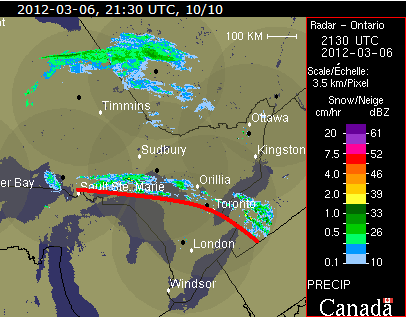
I’ve been watching the weather forecasts the last couple of days in anticipation of the +10C (or higher) that we’re supposed to see in Ottawa tomorrow. I looked at the Ontario radar a few minutes ago and you can see the line of precipitation escorting the warm front, which I’ve marked in red in this screen capture.
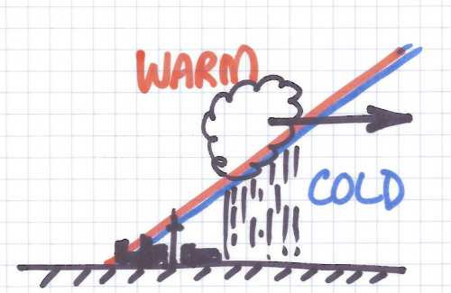
 What causes this line of weather is the less dense warm air over running the more dense cold air, condensing as it rises and causing precipitation, which you can see in the diagram I drew:
The diagram isn’t quite to scale as the clouds tend to form around 8000′ AGL, while the top of the CN Tower is roughly 1800′ AGL. Clouds at higher altitudes form in advance (to the right in my diagram) of the clouds that have the precipitation. But, you get the idea. 🙂
So, in the next few hours we can expect to see some precipitation and the winds changing directions significantly as the front passes through. And looking at the terminal area forecast (TAF) for CYOW, you can see that it’s going to happen between 0200Z and 1200Z (9pm and 7am):
TAF CYOW 062038Z 0621/0718 10010KT P6SM BKN070
FM070200 12008KT 2SM -SN BKN020 OVC040
FM070500 08008KT WS015/20030KT P6SM BKN060
FM071200 20012KT P6SM SCT060
RMK NXT FCST BY 070000Z=
Before 9pm, we can see the clouds are around 7000′ AGL (that’s the BKN070), but the precipitation won’t have arrived. At 0200Z (9pm), the precipitation preceeding the front is forecast to start falling in the form of snow from lower altitude clouds at 2000′ and 4000′ (BKN020 OVC040). This band of weather passes through in about 3 hours, as by 0500Z, the winds are forecast to be 8 knots (about 15 km/h) from the 080 (almost due east) with some windshear about 1500′ AGL where the wind will be blowing at 30 knots (55 km/h) from 200 (almost southwest). From a pilot’s point of view, that will make for a bumpy ride as they pass through 1500′ AGL. In my diagram above, this would be where the red-blue line meets the top of the CN Tower. By 1200Z (7am), Ottawa will be behind the front and the winds at the surface will be 12 knots (22 km/h) from the southwest.
And if the weather office is correct, it will be about +12C in Ottawa tomorrow. 🙂


 AKA Keeper of Maps, I'm a geocacher who lives in Ottawa, Canada.
