gordon.dewis.ca - Random musings from Gordon

Subscribe

Archive for May 2012

Time lapse photography

May 30, 2012 @ 15:10 By: gordon Category: Photography

I’ve been experimenting with time lapse photography lately, with my latest effort being one of the storms that passed through Ottawa yesterday afternoon:

But that’s nothing compared to this video of Springtime in Ottawa by Abe Alghazali who used 10000 images to create it:

A tip o’ the hat to OttawaStart for blogging about it.

An active afternoon

May 29, 2012 @ 16:36 By: gordon Category: Weather

The thunderstorms arrived a bit ahead of schedule, but not excessively so:

SPECI CYOW 291837Z 24010G20KT 10SM TS BKN061CB 31/18 A2953 RMK CB7 CB SSW-N + E-SSE SLP000 DENSITY ALT 2700FT=

Basically, the TAF from this morning forecast their arrival as early as 3pm, but they arrived at 2:37pm — 23 minutes early. The SPECI observation reported the wind from the SW at 10 gusting 20 knots, 10 miles visibility, moderate thunderstorms, ceiling at 6100′ consisting of cumulonimbus clouds (CB). The remarks basically that that there were CBs pretty much surrounding the airport except to the south and northeast. The density altitude of 2700′ is pretty impressive given that the airport is at 374′ ASL, so the air pressure was very low — as evidenced by the altimeter setting of 29.53″ Hg (compared to the standard of 29.92″ Hg). Not too surprising given the temperature was 31C at the time.

I thought I’d take a look at the TAF to see if they had issued a new one from the one in my previous post and sure enough it was amended this afternoon:

TAF AMD CYOW 291842Z 2918/3018 24012G22KT P6SM BKN040
TEMPO 2918/3001 VRB20G35KT 1SM +TSRA BR BKN006 OVC030CB
FM300100 23008KT P6SM BKN140
BECMG 3002/3003 27008KT
FM300500 28005KT P6SM SKC
FM301500 29012KT P6SM FEW060
RMK NXT FCST BY 292100Z

Previously, the thunderstorms were a 40% probability, but I guess when they actually happen it’s time to change that to TEMPO (occurences of less than an hour). 🙂

It’s shaping up to be an exciting afternoon

May 29, 2012 @ 13:09 By: gordon Category: Weather

It looks like the weather this afternoon could be exciting:

TAF CYOW 291441Z 2915/3012 VRB03KT P6SM FEW200
BECMG 2915/2917 20012KT
FM291900 20012G22KT P6SM BKN040 PROB40 2919/2923 VRB20G35KT 1SM +TSRA BR BKN006 OVC030CB
FM292300 23008KT P6SM BKN140
BECMG 3000/3002 28010KT
FM300500 28005KT P6SM SKC
RMK NXT FCST BY 291800Z=

The section I’ve highlighted in red basically says that between 3pm and 7pm today there is a 40% probability that the winds will be 20 knots gusting to 35 knots (37 to 65 km/h) from variable directions (in other words, from any direction) with 1 mile visibility and heavy thunderstorms and rain (+TSRA) and very low clouds (ceiling at 600′) and cumulonimbus clouds.

And Environment Canada’s special weather statement this morning included the following:

Today..Scattered thunderstorms are expected across southern Ontario. There is a slight risk they may be severe with damaging winds, large hail and torrential downpours. An isolated tornado is also possible in Extreme Eastern Ontario near the Quebec border. Also, isolated non-severe thunderstorms are possible over Northeastern Ontario near the Quebec border.

The storm that blasted through the area last Friday evening spawned a couple of tornados in Quebec, so hopefully people will heed the warning. Speaking of watches and warnings, it appears that we’ve been under a severe thunderstorm watch since mid-morning:

Ottawa North – Kanata – OrlĂ©ans
10:48 AM EDT Tuesday 29 May 2012
Severe thunderstorm watch for
Ottawa North – Kanata – OrlĂ©ans issued

Potential for severe thunderstorms this afternoon.

This is an alert to the potential development of severe thunderstorms with large hail, damaging winds or heavy rainfall..Monitor weather conditions and listen for updated bulletins.

A cold front will move through Eastern Ontario this afternoon which will trigger thunderstorms. Some of these thunderstorms may become severe with damaging winds and heavy downpours being the main threats. The cold front will move out of Ontario by early evening bringing an end to the threat of severe thunderstorms.

So, keep an eye on the Franktown radar this afternoon. If you see a line of orange, reds and purples or little groups of reds and purples, chances are good that’s where the thunderstorms are. If you happen to be in their path, take cover.

V from V for Vendetta apparently ran a minus 10k race

May 28, 2012 @ 12:38 By: gordon Category: Out and about, Photography

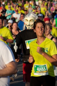
I went through my photos of the 10k race on Saturday last night, looking for some people I knew. I found my friends, but I also came across V from V for Vendetta in the crowd:

And a bit closer:

You have to admire his dedication because he was running backwards:

It must have been a bit disconcerting for the people following him to have him facing them. Gotta love the people who add a bit of colour to the races, eh?

One of my favourite cycling routes

May 28, 2012 @ 08:45 By: gordon Category: Cycling

I have three or four regular routes that I follow when I go cycling. When I’m looking for a longer route, I often take this one, which includes crossing the river over Portage Bridge, riding along the Quebec side of the river to the museum and then crossing back over the Alexandra Bridge before picking up the path on the Colonel By Drive side of the canal. Following the path to Hartwell Locks, it winds its way through the Experimental Farm to home.

The track in the map is from a ride I took last Thursday evening after work.

Ottawa Race Weekend 2012 10k race: 2 km to go

May 27, 2012 @ 13:53 By: gordon Category: Out and about, Photography

Here’s the timelapse video I put together of the runners in the 10k race passing Pretoria Bridge about 2 km from the finish.

Check out my time lapse video of the runners passing the 2km point on their way out.

Ottawa Race Weekend 10k race: Outbound in about 45 seconds

May 27, 2012 @ 13:21 By: gordon Category: Out and about, Photography

I headed out to Pretoria Bridge yesterday to watch the 10k race. In addition to taking a lot of shots of the runners that I still have to process, I had my point-and-shoot set up on a tripod taking pictures every 15 seconds.

Here are the runners as they pass by heading away from the start, compressed into about 45 seconds:

I’ve put together a similar video of their return on the way to the finish, which Youtube is currently processing. I’ll post a link to it here when it’s ready. has finished processing. Check it out here.