Here it comes
The incoming warm front I wrote about earlier can be seen on the edge of the composite radar image for Ontario:


The incoming warm front I wrote about earlier can be seen on the edge of the composite radar image for Ontario:
So, I see from the Weather Office’s website that Ottawa is under a freezing rain warning for tomorrow afternoon. Judging by the TAF, it’s not going to arrive until noon, and even then it’s only showing as a 40% probability from noon until 1PM (the end of the forecast period).
TAF CYOW 101738Z 1018/1118 29012KT P6SM FEW040
BECMG 1020/1021 30005KT
FM110000 VRB03KT P6SM SKC
FM111200 09005KT P6SM OVC200
FM111700 10010KT P6SM -RA SCT020 OVC050 PROB40 1117/1118 6SM -FZRA BR BKN020 OVC050
RMK NXT FCST BY 102100Z=
 You can see the warm front passing through based on the wind directions in the various periods in the forecast. At the beginning, it’s out of the northwest at 5 knots, becomes variable at 3 knots at 0000Z (7PM) and then is out of the east at 5 knots early tomorrow morning. So, in about 12 hours it flips around almost 180 degrees. Fun.
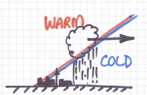
We’ll get freezing rain if the air being overrun by the incoming warm air is sufficiently cold enough to cause the rain drops condensing at the boundary between the warm and cold air to be supercooled so they freeze instantly on contact.
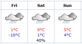 The next TAF should clarify how long the freezing rain is going to go on for tomorrow, but any way you slice it, it looks like my plans for snowshoeing on Saturday are probably going to be a bust, as you can surmise from the graphic.
 AKA Keeper of Maps, I'm a geocacher who lives in Ottawa, Canada.
