So, I’ve been reading the full version of the Gatineau Park Ecosystem Conservation Plan during the last week or so, along with a number of research articles that it cites. Of particular interest (to me anyway) is Appendix 2, which is titled “Eardley Escarpment description and conservation issues”. This is where the authors of the GPECP lay out why, in their opinion, climbing should be all but banned from Gatineau Park.
It starts off by describing what an escarpment is, in general terms, and then moves on to describing the Eardley Escarpment thusly:
Eardley Escarpment is a cliff lying along a south-south-west line. It is approximately 300 metres high, with an average height of more than 200 metres, and is the dominant topographical element in the Outaouais region. It begins in the City of Gatineau and runs north-eastwards along the Ottawa River for several dozen kilometres, forming a characteristic rock slope alignment.
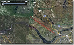
 To the best of my knowledge, the Eardley Escarpment, the aspect of which is approximately southwest, follows a line that’s aligned roughly northwest-southeast. If it ran “north-eastwards along the Ottawa River”, it would actually be oriented almost perpendicular to the Ottawa River.
If you look at the image to the right, you can see the Eardley Escarpment (I’ve marked it with a red line) running most of the way from top left to lower right.
But this isn’t the most problematic part of Appendix 2.
(more…)


 The
The  AKA Keeper of Maps, I'm a geocacher who lives in Ottawa, Canada.
