gordon.dewis.ca - Random musings from Gordon

Subscribe

Archive for the ‘Geocaching’

Go And Get ‘Em 8

April 30, 2006 @ 12:29 By: gordon Category: Geocaching

Go And Get ‘Em 8, a local geocaching event where people cache like crazy from 6pm Friday to 6pm Saturday and then get together for dinner, took place this weekend.  68 caches were placed for the event all over Ottawa and also on the Quebec side of the river.  Over 100 people went caching, either alone or in teams.

I recorded the following stats for the event:

  • 19 caches attempted
  • 16 caches found (17 if you include the event cache)
  • 2 caches not found
  • 1 cache not completed
  • 1 cache placed for the event
  • 237 km driven
  • 28.8 km/h moving average
  • 15.1 km/h overall average
  • 8 hours 14 minutes moving time
  • 7 hours 27 minutes stopped
  • 1 tree climbed
  • 1 nano cache found
  • 4 micro caches found
  • 6 small caches found
  • 4 regular size caches found
  • 1 large cache found
  • 1 travelbug found
  • Lots of fun had

I’m already thinking about caches for the Go And Get ‘Em 9 which will take place in the fall. 🙂

GAG 8 Geocoins

April 15, 2006 @ 02:16 By: gordon Category: Geocaching, Geocoins

About five or six weeks ago I was listening to an edition of the Podcacher podcast. In the episode, Sonny and Sandy went to a geocoin event somewhere in California and interviewed collectors. This got me thinking that it would be a lot of fun to produce a geocoin for the Go And Get ‘Em event being held at the end of April. I talked to my friend geoSquid (aka Darin) about it and we created a quick concept drawing and decided on how the coins would be finished. (We decided to produce 5 satin gold finish coins for ourselves only, 20 antique gold coins, 20 antique silver coins and 60 antique copper coins. The decision to make the bulk of them in antique copper rather than the more commonly used antique brass was made at the last minute and based on the pictures we received, we’re glad we did!) I did up some artwork using Adobe Illustrator CS2 while Darin contacted a number of mints who produce geocoins that are trackable on geocaching.com for quotes. We ended up selecting OakCoins and placed an order.

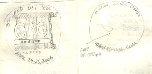
Here is the original concept sketch:
Concept sketch for GAG 8 geocoin

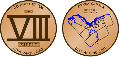
Compare it to the final artwork we sent to OakCoins:
Final artwork sent to OakCoins

As you can see, there were some changes. We both felt that having the GAG across the roman numerals was a) redundant since the name of the event it just above it, and b) too busy. So it disappeared. Oh, and we put the right dates in, too.

The artwork on the back was basically what we originally discussed. The coordinates for Ottawa were added to fill in the “white space” in the notch where Gatineau is. I looked at including the Quebec side of the river in the artwork but the very distinctive shape of the City of Ottawa got lost and it was harder to identify what it was a map of. I also considered adding the major roads, but couldn’t decide whether those were the 417, 174 and 416 or those highways plus rodas like Baseline Road, Bank Street, the Airport Parkway, Ottawa River Parkway. When I played with those options, the map became very cluttered. For those wondering, the black lines are the neighbourhoods that make up Ottawa.

Because the coins are produced using dies and the colours on the back are enamels, our artwork needed to be converted to an engraved form that took into account the fact that the enamels are in recesses and grooves in the metal. A couple of days after we submitted the artwork, they sent us a proof to approve.
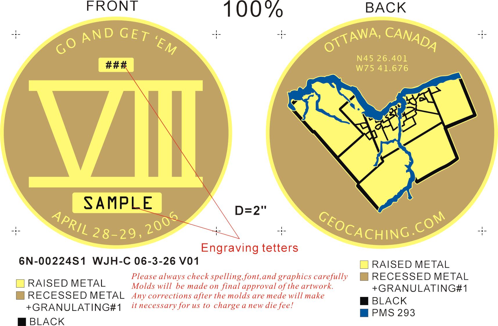
We both reviewed it and felt it accurately portrayed our vision for the coin and gave them the go-ahead to mint the coins. This was the Point of No Return. Dies were being made, credit card numbers submitted and thus we were committed to the project.

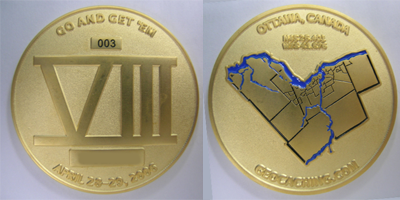
About two weeks later, they sent us pictures of our coins. The best ones to compare to the artwork above are probably the satin gold coins.
Satin gold coins - front and back

We haven’t actually received the coins yet, but we should sometime in the next few days.

Another thing we did in parallel with the artwork process was get the word out to the local geocaching community that we were producing coins. We did this a number of ways, including telling people and showing them the artwork at a get together at the beginning of April. We also posted a note to the GAG 8 event page telling people about it and I created a website (http://gag8geocoin.pinetree.org) using Adobe GoLive CS2. It didn’t take long for the reservations to start rolling in. In just a few days over half of the coins have been spoken for.

Originally, we had wondered whether we would cover our costs on the project — or perhaps more accurately, how much we would lose on the project. I realized early on that if we had any coins left over, we’d almost certainly be able to unload them on eBay. It’s looking like we won’t have any problems selling all of the coins to local geocachers.

We decided not to collect money from people until we had the coins in hand. Most people have asked for two or three coins. At $11 each, this could quickly become a large amount of money to give to people you don’t know very well for something that doesn’t actually exist at the time. To put it in perspective, most geocoins cost around $6 or $7. But those are coins that have much larger production runs than our 105 (of which 5 aren’t for sale).

Only a few more days until we receive the coins from the mint. I can’t wait to see the real thing!

Oh, and if you would like to reserve a GAG 8 Geocoin, send an email to gag8geocoin@pinetree.org.

150 caches and counting

April 14, 2006 @ 23:33 By: gordon Category: Geocaching

Kathy and I drove up to Foymount in an attempt to be the first to find a new geocache called Foymount (GCVBER).  Foymount is about 2 hours up the Ottawa Valley and is the highest populated point in Ontario.  During the cold war, from 1952 to October 1974, it was home to Pinetree Line site C-3.  The Pinetree Line was a network of radar stations set up to counter the Soviet air threat against North America.  For several years there were radomes (large golf ball things) watching the skies for invaders.

Anyways, the cache was posted on the 12th and by noon today it still hadn’t been logged.  Encouraged, we headed up to Foymount and found the cache quite quickly in amongst the foundations from the radomes and the various antennae at the very top of the mountain.  When we opened the container we discovered that someone else had driven even farther than we had and beaten us to the FTF by a couple of hours.  Oh well.  We had a great day and it was nice to be out in the country.

Geocaching with the CBC

April 10, 2006 @ 13:26 By: gordon Category: Geocaching

This morning, I went geocaching with a fellow geocacher and a reporter from the CBC’s All In A Day afternoon show.  CBC is running Canada Reads 2006 and as part of it, CBC Ottawa has hidden five books in local area geocaches.  Of the five caches we did, three were new to me and the remaining two I’d done sometime in the past.  We headed out around 0830 (yes, even me!) and finished caching around 1300.  The segment is probably going to air this afternoon, so if you’re listening to All In A Day, you may hear me talking about geocaching.

Next stop: Belgium

March 23, 2006 @ 15:49 By: gordon Category: Geocaching, Travel bugs

A few days ago, Donald the Sun Worshipper was picked up from a geocache in France where he’s been for the last seven months.  According to his rescuer, he’s going to be dropped into a cache in Belgium.

Geocaching on the last day of winter

March 19, 2006 @ 23:53 By: gordon Category: Geocaching

Kathy and I headed out this afternoon to do some geocaching in the rural parts of eastern Ontario. Our first cache (GC3E83) was, which is located Warwick forest about 50km SE of Ottawa. After stopping for supplies at a Tim Horton’s, we headed along the 417 to exit 66 where we turned south for a while until we came across the nearest concession road to the cache. Driving along it, we found a likely access point and walked about half a kilometre in along a snowmobile trail. Crossing a small creek, Kathy spotted the cache at the base of a clump of cedar trees.

The second cache we found (GCD7A) was located in the forest just east of Limoges. After bouncing along a frozen forest access road, we parked near a small cemetary in the middle of the forest (literally) and made our way into the cache. On the way in, we encountered a guy wearing bright orange hunting gear and carrying a bow and a quiver of arrows. Greeting him, we found out that he was “hunting trees” with blunt-tipped arrows. Apparently, the only thing in season right now are bunnies. We found the cache container fairly quickly and made the obligatory trades.

We attempted to find a third cache, but were not successful. Located about 200m into the forest, we headed in and while we are fairly certain we were in the right location, the cache was nowhere to be found. It’s been at least eighteen months since it was last found, so it’s very likely that the cache has gone missing. (Update: It appears that the cache was pulled sometime last fall, but for some reason it wasn’t flagged like that in my cache list.)

So, we covered about 100 km, found two out of three caches and did some hiking in the woods. All in all, a good way to end the winter. 🙂

A fDNF (first Did Not Find)

January 05, 2006 @ 23:55 By: gordon Category: Geocaching

Saw the new cache notification for Turn to Manotick (GCRT6B) at lunch so I grabbed my geocaching backpack and headed off to find it. Given that the cache was only an hour old, chances were good that I would be the first geocacher to find it. The coordinates took me to the only likely object within 20 metres so I figured I’d find it fairly quickly. After carefully searching the object, including digging in the snow at the base of it, I plodded off to a similar object about 30 metres away, just in case the coordinates were off. No luck there, either. Back to the first object for another look, without success. I drove off frustrated by the thought that the next cacher was going to have no problems finding it because it was hidden in plain view and I simply couldn’t see it.

To ease the pain of defeat, I went off in search of the next nearest cache, Long Island Mill (GCRR0N), and found it within a minute of parking the Tracker.

I emailed the owner of Turn to Manotick when I got home and showed him some pictures. He confirmed I was in the right place and described where it was. Two other geocachers after me both logged DNFs, so the cache container has disappeared before it was even published.