gordon.dewis.ca - Random musings from Gordon

Subscribe

Archive for the ‘Weather’

Winter has officially begun

December 21, 2008 @ 07:56 By: gordon Category: Weather

image

Welcome to winter. It officially started at 07:04 this morning, though you can be forgiven if you couldn’t tell the difference here in Ottawa. And to make it extra special, we have a snowfall warning in effect.

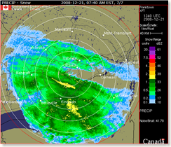
The snow started about half an hour ago, but the real stuff has yet to arrive. Watching the Franktown radar, one can see the yellow stripe running roughly east-west marching steadily towards Ottawa. This would be the "band of snow ahead of the low pressure system" alluded to in the snowfall warning.

Whee.

Feeling the pressure changes

October 28, 2008 @ 17:29 By: gordon Category: Health, Weather

Over the last couple of years, I’ve noticed that I start feeling crummy between 18 and 24 hours before a significant weather change. I haven’t kept any records to see if it’s predictable, but I suspect it is.

Well, yesterday evening around 10pm or so, I started feeling crummy, which persisted through to sometime this afternoon. Even now, I’m still feeling a little blah. I happened to see the nurse at work this afternoon and we chatted about this for a bit. She told me that I’m not the first person to mention something like thisair-pressure---ottawa---28- to her and described, almost perfectly my symptoms, namely feeling kind of "fuzzy" like you have a headache about to form.
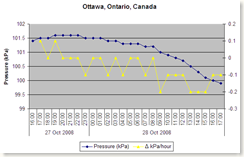
So, I looked up the air pressure readings for Ottawa for the last twenty-four hours. I started feeling under the weather (sorry!) around the same time the pressure started dropping. If you click on the graph at the right, you’ll be able to see a larger version.
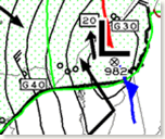
thumbnail-Latest-gfacn33_cl The graphical area forecast (GFA) for the Ontario-Quebec region for 8pm this evening (click on the image to the left) shows Ottawa sitting on the 996 millibar isobar, so it doesn’t look like the pressure is going to drop much more than it has.  (At 5pm it was 99.9 kPa or 999 millibars.)

Oh, and I just looked out the window to see the first snowflakes of the season.  Sigh.

Hmm…

October 27, 2008 @ 22:12 By: gordon Category: Weather

TAF CYOW 272338Z 280024 VRB03KT P6SM FEW040 BKN200
FM0800Z 34008KT P6SM -RA BKN025 OVC100 TEMPO 0814 6SM -RA BKN012
OVC025
FM1400Z 34012G22KT P6SM -RA BKN012 OVC025 TEMPO 1420 4SM -RA BR
BKN008 OVC020
FM2000Z 33015G25KT 3SM -RASN OVC012 TEMPO 2022 1/2SM SN VV005
FM2200Z 32015G25KT 1/4SM +SN VV003
RMK NXT FCST BY 03Z=


So, it looks like the snow is going to start around 16:00 localtime and then be in full blizzard mode by about 18:00 tomorrow.  Well, maybe not an official blizzard per Environment Canada’s definition (four or more hours of snow or blowing snow with winds of 40 km/hr or more, visibility reduced to less than one km. in snow and/or blowing snow, and a windchill of -25 or colder) but definitely lots of snow and wind.

And so it begins

October 27, 2008 @ 15:59 By: gordon Category: Weather

This just in from Environment Canada:

WINTER STORM WATCH ISSUED For Ottawa BY ENVIRONMENT CANADA
BULLETIN ISSUED AT: 3:50 PM EDT MONDAY 27 OCTOBER 2008
THE FIRST MAJOR SNOW STORM OF THE SEASON LIKELY LATE TUESDAY AND TUESDAY NIGHT.  THIS IS AN ALERT TO THE POTENTIAL DEVELOPMENT OF DANGEROUS WINTER WEATHER CONDITIONS IN THESE REGIONS. MONITOR WEATHER CONDITIONS..LISTEN FOR UPDATED STATEMENTS.

The civil forecast for tomorrow afternoon/evening is suggesting:

Snow at times heavy. Amount 15 cm. Blowing snow overnight. Wind west 50 km/h gusting to 70. Low zero.

So, the commute home tomorrow could be quite exciting.

Sigh.

Exciting weather at the airport, too

August 18, 2008 @ 16:49 By: gordon Category: Current affairs, Weather

It appears that the weather has been exciting at the airport, too:

METAR CYOW 182000Z 22011G19KT 15SM SCT050CB SCT075 BKN230 27/19 A2969 RMK CB3AC1CI2 DIST LTNG SHS NW-NE SLP053=
SPECI CYOW 182003Z 31021G27KT 15SM TS FEW023 SCT045CB BKN075 BKN230 23/ RMK SC1CB3AC1CI1 OCNL LTGCG SHS NW-NE=
SPECI CYOW 182012Z 35023G32KT 12SM -TSRA FEW025 BKN045CB BKN075 BKN230 21/ RMK SC1CB4AC1CI1 OCNL LTGCG=
SPECI CYOW 182024Z 34023G29KT 1SM +TSRA BKN040CB BKN230 17/ RMK RA3CB3CI1 OCNL LTGCG CB OVHD=
SPECI CYOW 182024Z CCA 34023G29KT 1SM R07/4000VP6000FT R32/P6000FT +TSRA BKN040CB BKN230 17/ RMK RA3CB3CI1 OCNL LTGCG CB OVHD=
SPECI CYOW 182031Z 35011G16KT 3/4SM +TSRA BKN040CB BKN230 17/ RMK RA4CB2CI1 FQT LTGCG CB OVHD=
SPECI CYOW 182031Z CCA 35011G16KT 3/4SM R32/2800VP6000FT/D +TSRA BKN040CB BKN230 17/ RMK RA4CB2CI1 FQT LTGCG CB OVHD=
SPECI CYOW 182038Z 06009G16KT 4SM TSRA BKN040CB OVC140 17/ RMK CB5AC3 OCNL LTGCG CB MOVG SW VIS LWR S=

At one point, it looks like the wind was gusting up to 32 knots (59.2 km/h).

It’s stopped raining here, or at least let up enough that I won’t be soaked to the bone in three seconds with only my tired umbrella and my Tilley to keep me dry.

Exciting weather

August 18, 2008 @ 16:12 By: gordon Category: Current affairs, Weather

This popped up on my email a few minutes ago:

SEVERE THUNDERSTORM WARNING ISSUED For Ottawa BY ENVIRONMENT CANADA

BULLETIN ISSUED AT: 3:57 PM EDT MONDAY 18 AUGUST 2008
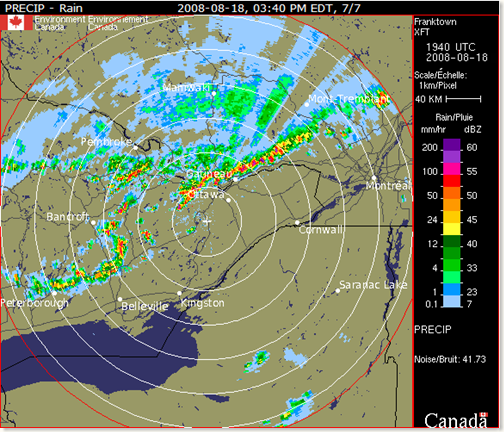
AT 3:40 PM THE RADAR IS INDICATING THAT A WEST TO EAST LINE OF SEVERE THUNDERSTORMS IS MOVING SOUTHEAST AT 80 KM/H. LARGE HAIL GREATER THAN 2 CENTIMETRES IN DIAMETER AND STRONG WINDS GUSTS OF 90 TO 120 KM/H ARE POSSIBLE WITH THESE STORMS. THERE IS ALSO A RISK OF A TORNADO.  THIS IS A WARNING THAT SEVERE THUNDERSTORMS ARE IMMINENT OR OCCURRING IN THESE REGIONS. REMEMBER SOME SEVERE THUNDERSTORMS PRODUCE TORNADOES..LISTEN FOR UPDATED WARNINGS. EMERGENCY MANAGEMENT ONTARIO RECOMMENDS TAKING COVER IMMEDIATELY WHEN THREATENING WEATHER APPROACHES.   SEVERE THUNDERSTORM WATCH FOR OTTAWA NORTH – KANATA – ORLEANS CONTINUED  SEVERE THUNDERSTORMS THIS AFTERNOON AND EVENING.  THIS IS AN ALERT TO THE POTENTIAL DEVELOPMENT OF SEVERE THUNDERSTORMS WITH LARGE HAIL AND DAMAGING WINDS.  MONITOR WEATHER CONDITIONS..LISTEN FOR UPDATED STATEMENTS. IF THREATENING WEATHER APPROACHES TAKE IMMEDIATE SAFETY PRECAUTIONS.


The Franktown radar at 15:40 Eastern showed:

image 

The view from my office window is very impressive.  I can see a sharp line along the edge of the clouds to the south.  A couple of minutes ago I watched as the bottom layer of clouds was swirling in a vertical manner while the layer above it was moving south.  And there’s thunder rumbling and we’ve seen a couple of flashes of lightning.

I wouldn’t be surprised if someone reports a funnel cloud because it sure looks like there might be a "comma" or two in the radar image.

Oh, and it’s just started to pour rain, to the extent that I can’t see the edge of the clouds any more.

You know it’s Spring when…

April 14, 2008 @ 13:01 By: gordon Category: Current affairs, Weather

There are many indications that Spring has finally arrived: the arrival of the first robin, crocuses poking up through the ground and bicycling, to name a few. For people who work in Tunney’s Pasture, there’s another: the return of the Hotdog Guy.

(more…)