gordon.dewis.ca - Random musings from Gordon

Subscribe

Archive for the ‘Weather’

Here we go again

April 11, 2008 @ 00:02 By: gordon Category: Weather

A few minutes ago I checked the terminal area forecast (TAF) for Ottawa for the next 24 hours or so:

TAF CYOW 110238Z 110324 32008KT P6SM BKN220
FM1000Z 03005KT P6SM BKN120
FM1400Z 08012KT 11/2SM -SN VV015 PROB30 1419 P6SM -FZRA -PL
FM1900Z 08012KT 4SM -SNRA BKN012 OVC050 TEMPO 1922 2SM -SN BKN008
FM2200Z 07012KT 11/2SM -RA BR BKN006 OVC012
RMK NXT FCST BY 06Z=

So, we can probably expect to see snow and rain, both individually and together, and maybe some freezing rain and ice pellets.

Only about 6 weeks until I go to Greece…

Sunshine makes Strongbow taste better

April 06, 2008 @ 22:52 By: gordon Category: Weather

I sat on the patio at a local pub and sipped cider in the sunshine with a friend this afternoon! Such a nice change after having to hide inside all winter. 🙂

The weather forecast for the next few days doesn’t have a low below 0°C, so hopefully the remaining snow will disappear.

This means cycling on the bike paths isn’t far off!

Pictures from March Winter Storm #2

March 09, 2008 @ 12:55 By: gordon Category: Photography, Weather

I took a few pictures of the storm from my apartment last night and put them in my gallery. The storm appears to be over, but I’ll take a few pictures when I’m out and about today.

Because we don’t have enough snow yet

March 07, 2008 @ 08:25 By: gordon Category: Weather

It appears there’s yet more snow on the way to address the extreme shortage of snow in Ottawa:

TAF CYOW 071138Z 071212 11005KT P6SM BKN040 OVC060
FM2000Z 35005KT P6SM -SN OVC050 TEMPO 2022 3SM -SN BKN020 OVC050
FM2200Z 01005KT 4SM -SN OVC025 TEMPO 2202 2SM -SN OVC012
FM0200Z 35010G20KT 3/4SM -SN BLSN VV008 TEMPO 0210 2SM -SN OVC010
PROB30 0510 1/2SM SN BLSN VV004
FM1000Z 35012G25KT 5SM -SN OVC030 TEMPO 1012 3SM -SN OVC015
RMK NXT FCST BY 15Z=

Currently, there’s a winter storm watch in effect, that I expect will be upgraded to a winter storm warning later today:

Ottawa North – Kanata – OrlĂ©ans
5:02 AM EST Friday 7 March 2008
Winter storm watch for
Ottawa North – Kanata – OrlĂ©ans continued
..Winter storm expected to give heavy snow Saturday..
This is an alert to the potential development of dangerous winter weather conditions in these regions. Monitor weather conditions..Listen for updated statements.

Storm totals may be 20 to 30 centimetres along and east of a line from Long Point to the Golden Horseshoe then to Petawawa. There is potential for 30 to 50 centimetres of snow over the Niagara Peninsula and parts of eastern Ontario. Areas west of the Long Point to Petawawa line should see between 10 to 20 centimetres with lesser amounts near Lake Huron and Georgian Bay. Behind this system strong northerly winds to 70 km/h are possible. On Saturday strong winds combined with fresh snow will cause blowing snow to lower visibilities and create dangerous driving conditions. Whiteout conditions are possible so travellers should be prepared to alter their plans accordingly.

At least I don’t have a driveway to shovel, but it’s going to be miserable driving tomorrow.

Please, sir, can I have some more? No, really.

March 04, 2008 @ 19:50 By: gordon Category: Current affairs, Weather

If I were Norse, I’d blame the weather forecast on Loki because I don’t think Freyr was quite as much of a troublemaker, even though he was in charge of the weather. But, I’m not, so I won’t tempt incurring Loki’s wrath on top of this weather.

TAF CYOW 042338Z 050024 03012KT P6SM FEW040 BKN120
FM0300Z 06010G20KT 6SM -SN SCT020 OVC060 TEMPO 0305 2SM -SN
OVC020
FM0500Z 07012G22KT 11/2SM -SN VV012 TEMPO 0506 3/4SM -SN VV008
FM0600Z 07015G30KT 3/4SM -SN BLSN VV007 TEMPO 0608 1/4SM +SN BLSN VV003
FM0800Z 07015G25KT 1/4SM +SN BLSN VV002
FM1100Z 06020G30KT 11/2SM -PL BR VV010 TEMPO 1114 3/4SM -PLSN
BLSN VV007 PROB40 1114 1SM -FZRA BR
FM1400Z 06015G25KT 3/4SM -SN BLSN VV007 TEMPO 1417 1/4SM +SN BLSN VV003
FM1700Z 34015G25KT 2SM -SN OVC015 TEMPO 1719 5SM -SN PROB30 1719 1SM -FZDZ BR
FM1900Z 28010G20KT 6SM -SN OVC020
FM2200Z 27010G20KT P6SM BKN030 OVC060
RMK NXT FCST BY 03Z=

Wind. Snow. Ice pellets. Snow pellets. Freezing rain (maybe). Freezing drizzle (maybe). More snow. Lots of wind.

Basically, the next 24 hours or so are going to suck.

I. Can. Hardly. Wait.

February 17, 2008 @ 12:53 By: gordon Category: Current affairs, Weather

imageIt’s official: I’m sick of winter.  And so is almost everyone I know.

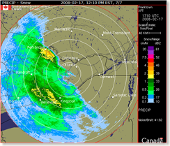
At 12:10 PM Eastern, Franktown radar, which is located between Smiths Falls and Carleton Place, is showing the leading edge of the freezing rain, snow, rain, frogs, ice pellets, and other charming weather that we’re going to be receiving this afternoon.

The aviation forecast for Ottawa is saying that we can expect the snow to start around 1 PM Eastern, followed by freezing rain that will probably start around 2 PM.  Around 6 PM it’s probably going to start raining.  And it’s going to be windy to boot.

TAF CYOW 171738Z 171818 06010KT 6SM -SN SCT020 OVC050 TEMPO 1819 2SM
-SN VV015
FM1900Z 08010G20KT 6SM -FZRA BR SCT008 OVC020 TEMPO 1923 2SM
-FZRA BR BKN008 OVC020
FM2300Z 16012G25KT 2SM -RA BR OVC006 TEMPO 2311 1/2SM -RA BR
VV002
BECMG 0507 20010KT
FM1100Z 23012G22KT 2SM -DZ BR OVC006 TEMPO 1114 6SM -RA BR SCT006
OVC012
FM1400Z 24015G25KT P6SM SCT020 TEMPO 1418 BKN020
RMK NXT FCST BY 21Z=

My lack of enthusiasm over this is overwhelming.  How about you?

Feeling surrounded

February 01, 2008 @ 08:15 By: gordon Category: Weather

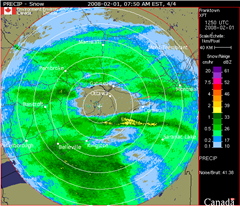
At 7:50 Eastern, the Franktown radar, located between Smiths Falls and Carleton Place, showed Ottawa as being pretty much the only place in eastern Ontario that isn’t being snowed on.  Judging by the radar loop, it’s only a matter of time until that changes.

Franktown-radar---01-Feb-20